 |
| ROSS ANDERSON COLLECTION |
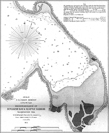
| 1854 The U.S. Navy's 1854 chart (left) of "Duwamish Bay and Seattle Harbor" may be the first official map of the village founded just three years earlier. Seattle shows as a cluster of dots on the point at right. The south third of the bay consists of tidal flats, muddy at low tide. The chart was part of the government's campaign to survey harbors in the new Washington Territory. |
GEORGE VANCOUVER was not impressed. He said so with his map.
In 1792, the English explorer and his crew spent several weeks exploring Puget Sound, eventually producing the first-ever map of this corner of the continent. The map, so accurate that one could follow it down the Sound today, shows Tacoma's Commencement Bay in some detail, and the skipper was so impressed with the future site of Everett that he went ashore and claimed it for His Majesty.
But halfway between them, what we now know as Seattle shows as a mere dimple in a complex shoreline; it wasn't even worth a name.
Still, Vancouver's map provided the world's first look at the place that, 60 years later, became Seattle.
Since then, Seattle has inspired countless hundreds of maps - from plat maps to gas-station maps, from panoramic views to satellite images. Like Vancouver, each mapmaker selected which features to show or not show, delivering its own geographical and editorial comment on the city that now prepares to observe the 150th anniversary of its founding.
The other day, I asked 20 of my colleagues to sketch a quick map of their fair city. Their sketches had one common characteristic: Each was oriented with North at the top of the page. Beyond that they were, well, all over the map. A manager sketched a neat, tidy city, like a corporate organizational chart. A columnist offered a people-oriented tour of Seattle neighborhoods. An Eastsider depicted Seattle as an insignificant island just offshore from Bellevue.
A few themes emerged. Most started with Seattle's unique hourglass figure - defined by Puget Sound on one side and Lake Washington on the other, wide at the top and bottom, skinny in the middle. And virtually everyone's map included I-5 or a Lake Washington bridge - their routes from home to work and back.
Not surprising, perhaps, since most Americans view maps merely as tools for finding the shortest distance from here to there. But they are much more than that. Maps and mapmakers weave science and geometry, language and art into documents that people like me see as a high form of literature. Vancouver's maps, 200 years out of date, line my stairway at home, and hardly a day passes that I don't stop to admire them.
CITY MAPS have especially rich genes. The oldest known map, scrawled on a wall in Turkey and depicting a long-forgotten town at the foot of a volcano, has been carbon-dated to about 6,200 B.C. And long before anybody decided the earth was round, there were artful renditions of Jerusalem and Rome and other ancient cities.
The history of Seattle's map is far more prosaic. Yet, like Rome or Jerusalem, our culture remains deeply rooted in our geography. List a local issue - rapid transit or declining salmon, earthquakes or energy shortages - and chances are it can be explained in large part by looking at a map.
The first views were crude plats drawn by the founders, essentially legal documents establishing their land claims.
The first Seattle map seen by the outside world was produced in 1854 by a U.S. naval crew that dropped anchor in "Duwamish Bay" to chart its shoreline, part of the government's effort to survey thousands of miles of mostly-uncharted Pacific Northwest coastline. That chart shows a kidney-shaped inlet, half of it mudflats shielded by the roughly rectangular Alki peninsula. Midway down the eastern shore of the bay, at the edge of the mudflats, is a minor point of land with a spattering of about 10 dots representing buildings. The dots are labeled "Seattle," the name pioneers gave to the place where they built rustic homes on the site of an old Indian village.
That's about it. The next two decades were virtually mapless in Seattle. The village grew slowly to 250 people in 1860, then 1,100 in 1870 - too small to need a map. Regional maps and atlases from the period were more likely to show Victoria, B.C., Olympia or Portland.
But in 1878, an itinerant artist named E.S. Glover strode ashore and struck a deal to draw the definitive "bird's-eye view" of the city.
Like dozens of other traveling artists of his day, Glover's mission was partly about art but most ly about business. The idea was to find a newspaper or a real-estate salesman to finance the job, then produce a detailed and handsome view of the city from some theoretical place up there, and sell the prints. Glover was a busy artist; in the previous year, he had drawn cities from San Diego to Victoria. The bird's-eye artist began with an accurate layout of the town's topography and streets, picked his point of view, then toured the streets, sketching buildings, streets, docks - anything that seemed to matter. "They had to be accurate," says local historian Greg Lange. "People wanted their businesses and homes to be on the map - or they wouldn't buy them!"
The Seattle Glover drew in 1878 was a village of about 3,000 people, still focused on the lumber mill and dock at the foot of Yesler Street. Just south of Jackson, the town turned to mudflats. The tiny business district consisted of about six blocks; houses clustered between Seventh Avenue and the waterfront and north to Pine Street.
THE TOWN BEGAN to boom in the early 1880s, spurred by the arrival of the Northern Pacific Railroad in Tacoma, providing transportation for Puget Sound resources. Streetcars opened new residential areas. Real-estate speculators filed plats, which required new maps. The city needed topographical maps to design water and sewer lines.
It's easy to see the speculators at work in a map from 1891, says Richard Morrill, longtime geography professor at the University of Washington. They're filing plats on steep slopes, bogs, even the tideflats off Magnolia.
Meanwhile, along came another birds-eye artist, Augustus Koch, who drew a very different city. By 1891, Seattle's population had exploded to 50,000. Pioneer Square was a bustling commercial crossroads of ships and trains that crossed the mudflats on a network of trestles. Streetcar neighborhoods were booming along Madison Street, the Rainier Valley, up the slopes of Queen Anne Hill and out to Fremont and Ballard - about a dozen streetcar lines in all.
As the turn of the century approached, birds-eye views were falling out of fashion, victims of photography. Why pay for an artist's rendition when you can get a photograph? Too bad. Photographs may be more accurate, but the camera has no point of view. It can't edit the extraneous.
Thankfully, enough folks kept faith with the old ways, and maps persisted. Redick McKee's "Correct Road Map of Seattle and Vicinity" in 1894 attempted to identify the city's every business and residence, from the waterfront mills to the suburban homes of Columbia City and Latona - the cartographer's version of the aerial photo.
Even as that map was being drawn, Seattle's boom stalled briefly with the financial panic of 1893. But business took off again with the arrival of the Great Northern Railroad, the Klondike Gold Rush and the Alaska-Yukon-Pacific Exposition of 1909.
By 1911, Seattle was bursting its seams, in more ways than one. The population had multiplied to 240,000. Business, including real estate, was thriving. But the city's famous hills and lakes and waterways became obstacles. Seattle was fast becoming mired in its own geography.
So City Hall hired Virgil Bogue, a well-known engineer and planner, to draw up a bold makeover. Bogue's Grand Plan called for a broad boulevard, lined with classical architecture, extending from downtown to Lake Union. He designed an ambitious mass-transit system with subways, elevated trains, bridges and tunnels. And he attempted to sell the idea with an inch-thick document composed largely of maps.
Condemning it as too ambitious and costly, voters defeated Bogue's Plan. Ninety years later, there is a double irony to that decision. The plan would have given the city the transit system it now yearns for. But, had it been built, it almost certainly would have been dismantled, replaced by cars. Streetcar lines were shut down in 1940, the rails sold as scrap to Japan.
Instead of building transit, the city had moved earth, leveling hills and using the dirt to fill the mudflats, digging a ship canal that linked Puget Sound to the lakes, straightening the Duwamish River and building a huge artificial island at its mouth to accommodate shipping. By 1915, Seattle had literally reconstructed its own landscape.
Meanwhile, roads and road maps were beginning to define the American landscape, including Seattle's. Able to grow in only two directions, the city spread quickly to its present-day limits, and the market was for maps that helped drivers navigate from Point A to Point B.
Instead of streetcar lines, roads would direct the city's dynamics. Up to 1940, the Eastside had been virtually irrelevant. Kirkland, linked to Seattle by ferry, shows up on maps from the 1930s, but Bellevue was still populated by berry farmers.
Then, in 1940, came the Lake Washington Floating Bridge. The rest is history.
The Age of the Automobile has not done much for the art of maps. From the 1930s to the present, little has been added to the Seattle map - I-5, a few bridges, Seattle Center. One could drive much of today's Seattle with a 1940 map.
"The natural environment and topography have virtually disappeared," Lange says. "The only residue are the waterways and shorelines."
But maps remain imbedded in American culture. Dog-eared city maps are stuffed into our desk drawers and under our car seats. Pocket maps are for sale alongside the Bic lighters at the supermarket checkstand. Maps are in the telephone book, on the office wall, spilling out of the new National Geographic.
Rand McNally, which has been publishing maps for some 130 years, runs a little shop downtown that sells seven different maps of Seattle, six Seattle guidebooks with maps, 10 various state and regional atlases, plus maps for virtually any major city around the globe. Internet sites will print you a map of any given address, and show you how to get there. Rand McNally is heavily into the business of selling handheld computers and software that will do much the same - and more.
For map nuts like me, there is something numbing about all this. The Internet spits out a map virtually identical to the one you see at Rand McNally. Seattle in white, suburbs in pastel pink, all overlaid with red and yellow and black lines designating streets and highways. There is no landscape, no contour, no geography, no art and no new perspective. Just roads.
These are not maps. They are wiring diagrams.
Where is Augustus Koch when we really need him? We yearn for a mapmaker with a strong point of view. Consider Saul Steinberg's famous 1976 New Yorker cover, "View of the World from Ninth Avenue," a Manhattan street scene in the foreground, then east to the Hudson River, Jersey, a vague smattering of mountains out west.
But computers also do marvelous things. David Finlayson and his colleagues at the University of Washington have compiled 100 years of land and marine surveys, millions of bits of information on elevations and depths from Mount Rainier to the deepest point in Puget Sound, and fed it into one powerful computer.
The result is a cartographic gem, the most thorough and detailed rendition of our landscape ever produced. Man's handiwork is present in the form of Harbor Island and the Ship Canal. Otherwise, the computer shows us a Seattle stripped of our steel and asphalt interference. It is a map biased toward geography, depicting narrow ridges and valleys running north to south, tracks of the Vashon Glacier that, 14,000 years ago, covered what we know as Seattle with a mile of ice. Study this map and you're liable to hear the glacier grinding its way south, carving the landscape.
This is a map with perspective. It uses Seattle's most up-to-date digital technology to reveal its most ancient information.
And it is beautiful. Soon Finlayson's map of where I live will take its rightful place on my wall - right alongside those of Koch and Bogue and George Vancouver.
Ross Anderson is a Seattle Times staff reporter.
|
 Sunday, September 16, 2001 - 12:00 a.m. Pacific