|
Sunday, March 19, 2000
Viewing the implosion
Officials in charge of imploding the Kingdome urge everyone to stay home
and watch the action on TV or on the Web. But if you must be there,
here are some good public places to safely watch the Kingdome go boom:
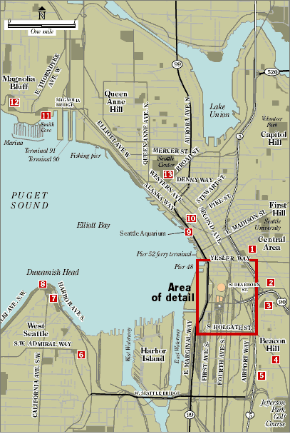
Area of detail: Boundaries of the restricted zone.
 Harborview Medical Center
Ninth Avenue and East Terrace Street.
What: Hospital has grassy terrace with benches and a covered smoking
section. View is spectacular, close and above the Dome.
Parking: $4 in visitor lot or limited street parking. Garage is best bet.
Back to top
 Jose P. Rizal Bridge Jose P. Rizal Bridge
12th Avenue South, heading to Beacon Hill.
What: Long, wide sidewalk on bridge with a bird's-eye view of the Dome.
Parking: Street parking in International District.
Bus: Routes 36 and 60.
Back to top
 Dr. Rizal Park Dr. Rizal Park
12th Avenue South and South Judkins Street on Beacon Hill, across the
street from Pacific Medical Center.
What: The best spot in town? Could be, with great view of Dome,
downtown and the Olympic Mountains. Nice grassy area, tables and
benches, a small playground and even a pavilion to keep dry if it's raining.
Parking: 20 free spots and decent street parking.
Bus: 36 and 60.
Back to top
 Hike the East Duwamish Greenbelt Hike the East Duwamish Greenbelt
12th Avenue South and Beacon Avenue South.
What: Walk the trail along Beacon Hill and catch some exercise when the
Kingdome goes down. Good views and private.
Parking: Street parking around neighborhood.
Bus: 36 and 60.
Back to top
 12th Avenue South Viewpoint Park 12th Avenue South Viewpoint Park
South Forest Street.
What: Nice stretch of grass in quiet Beacon Hill neighborhood.
View a little far.
Parking: Ample street parking.
Bus: 36 and 60 close by.
Back to top
 Belvedere Viewpoint Park Belvedere Viewpoint Park
Southwest Admiral Way at Southwest Olga Street in West Seattle.
What: Good view across bay. A little far, but not bad with
downtown looming.
Parking: 10-15 free spots.
Bus: Routes 56, 57 and 85.
Back to top
 Hamilton Viewpoint Hamilton Viewpoint
California Way Southwest in West Seattle.
What: Straight across bay, but bring binoculars.
Parking: Plenty of free spots.
Bus: Route 55.
Back to top
 Seacrest Marina Park Seacrest Marina Park
1800 Harbor Ave. S.W. in West Seattle.
What: Long promenade on bay. View is good.
Parking: Plenty of free spots.
Bus: Route 37.
Back to top
 Pier 62-63 Pier 62-63
Alaskan Way.
What: Huge pier able to hold hundreds with
excellent view of Dome. Part of lower
structure obscured by a building.
Parking: Some street parking, plus lots
ranging from $2.50 to $6.
Bus: Waterfront streetcar.
Back to top
 Victor Steinbrueck Park Victor Steinbrueck Park
Lenora Street and Pike Place.
What: Dome is close and straight on.
Parking: Lots galore. Try Public Market
Parking, where first hour is free, but two
costs $5.
Bus: Routes 15, 18, 21, 22, 56, 39, 42
within two blocks.
Back to top
 Smith Cove Park Smith Cove Park
West Galer Street and West Marine Place, just over Magnolia Bridge.
What: Long view over Elliott Bay. Walk
toward marina for clear shot.
Parking: Good free parking.
Bus: Routes 12, 24 and 33 come close.
Back to top
 Magnolia Park Magnolia Park
Magnolia Boulevard West.
What: Nice expanse of grass, big trees. View
is far and requires bit of straining. But you
don't have to leave Magnolia.
Parking: About 30 free spaces.
Bus: 19 and 24 close by.
Back to top
 Space Needle Space Needle
Opens at 8 a.m.
Cost: $9 for adults, $4 for kids 5-12.
Capacity: 300 people. No reservations.
It's first-come, first-served.
Parking: Some street parking, pay lots from
$6 to $12 and valet for $7.
Bus: Routes 16, 4 and 3, plus Monorail.
Back to top
Reporting: John Zebrowski; Map Graphics: Mark Nowlin / © 2000 The Seattle Times

|
