Originally published January 21, 2015 at 7:03 PM | Page modified January 22, 2015 at 3:46 PM
Top 10 snow-free (mostly) winter hikes within a yodel of Interstate 90
Founders of the popular Trail Mix hiking club name their favorite foothill treks for the cold months.
Seattle Times staff reporter
Hiking safety
Hiking can be dangerous at times. Here are five tips from the Washington Trails Association for going prepared and staying safe:
1. Check the latest trail conditions: Read how others have fared when choosing a hike. Contact the local ranger station for current conditions.
2. Let someone know where you’re going: Let them know your intended destination and when you plan to return, and update them if plans change.
3. Pack the 10 Essentials:
• Topographic map
• Compass
• Water and a way to purify it
• Extra food
• Rain gear and warm clothing
• Fire starter and matches
• Sun protection
• Pocketknife
• First-aid kit
• Flashlight and extra batteries
An emergency shelter, hiking poles, ice ax and snowshoes are also worth considering, depending on the season and where you’re going.
4. Watch the weather forecast: Conditions can change minute by minute. Don’t force a hike. If the conditions aren’t right, save it for another day.
5. Beware of hunters: Wear orange clothing and make noise while you hike if you’re traveling in hunting zones during hunting season.
Northwest travel guides
![]()
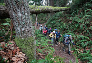
Trail Mix is one of the most popular hiking groups in Western Washington. Sorry for the tease, but they’re not taking any more newcomers right now.
They hike in packs of 12, and with more than 300 members, the group is bursting at the seams, said hike leader Pete Girard.
So we got the next best thing. We asked Trail Mix co-founders Girard and Peter Stevens to list their Top 10 local winter hikes that won’t usually require snowshoes. (Snow-free not guaranteed.)
We asked only that they not include off-the-beaten-path hikes for fear you might get lost without a compass or any of the “10 hiking essentials” (which you have in your day pack, right?).
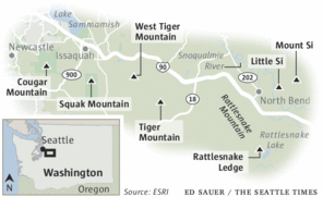
In winter, they focus their lowland hikes around the accessible Interstate 90 corridor from Cougar Mountain to Rattlesnake Lake. Washington Trails Association can give you more-detailed hiking and driving directions; search for each hike on wta.org.
Here is Girard and Stevens’ top 10 list, in no particular order, with their comments.
West Rattlesnake trail, from Snoqualmie Point
You can hike all the way to Grand Prospect (round trip of 8.4 miles, with 2,200 feet of elevation gain). This hike can also be a snowline explorer on which your party goes only as high as snow and ice conditions allow. You get magnificent views of Mount Si and other peaks to the north and east and at Grand Prospect, plus views up the Middle Fork Snoqualmie River. At the trailhead, there are two bathrooms and a paved lot with plenty of parking spaces.
Getting there: Exit 27 off I-90.
East Peak-Rattlesnake trail, from Rattlesnake Lake
This popular hike on the new trail goes to the lower, middle and upper Rattlesnake ledges, easily walkable in almost all conditions. Above the lower ledge, hiker traffic diminishes as you ascend. Very few folks go as high as the East Peak of Rattlesnake, which is a round trip of about seven miles, with a 2,400-foot elevation gain.
Getting there: Exit 32 off I-90.
Mount Si
This is a harder winter hike, one that often features a slick path up high. We definitely bring traction devices. It has nice views in all directions, including of Mount Rainier. This hike is eight miles round trip with 3,200 feet of elevation gain. We perk up this hike by going up and down the Old Mount Si Trail, from the Little Si parking lot, a route that has far less traffic. It also gives you a better workout (six to seven miles and 3,400 feet of elevation).
There’s also a nice loop you can make, off the regular Mount Si trail. It’s the Talus Loop trail (4.5 miles and 1,500 feet of elevation gain). It’s a trail that doesn’t get much traffic. You get a nice lunch spot, on the talus, with views to the east and, sometimes, sunshine. A few places on this trail can be icy. This loop is a good choice when the weather around Mount Si is too windy or cold.
Getting there: Exit 32 off I-90.
Little Si
This hike is a four-mile round trip with about 1,200 feet of elevation gain. We perk it up by going first up the Boulder Garden Loop and then down to join the Little Si trail, for about six miles and 1,700 feet of elevation gain, putting us atop Little Si and its great views of Mount Si. A nice lunch spot.
Getting there: Exit 32 off I-90.
Squak Mountain, south side
This trailhead has a large parking lot, good signage, southern exposure and not much foot traffic. There are various trails up to the central and west peaks of Squak with mileages in the six- to seven-mile range and elevation gains approaching but usually not exceeding 2,000 feet. Depending on the route, there are Mount Rainier views and a glimpse of downtown Seattle and the Olympics.
Getting there: Just west of Issaquah, take Highway 900 south 4 miles to May Valley Road. Go east 2.5 miles to Squak Mountain State Park sign, on left.
West Tiger 3 trail
This hike can get crowded, what with 250,000 hikers up here annually. But there are lots of different routes to the top. The usual route is about five miles round trip with 2,000 feet of elevation gain. Traction devices are usually needed above what is known as the Railroad Grade, at an altitude of about 2,000 feet (the top is at 2,500 feet). The Nook and Section Line trails are often quiet, since they’re steeper than the regular trail. Those with a Tiger Mountain map can find different ways to descend to the parking lot. Hikes on this side of West Tiger 3 are protected from south winds.
Getting there: Exit 20 off I-90.
West Tiger 2 trail (and West Tiger 1) from East Highpoint
This hike offers steep elevation gain and a winding trail, but you rarely need traction devices. In case of crummy weather, take shelter at the Hikers Hut. This hike is about eight miles with more than 2,500 feet of elevation gain. On a clear day, you can see Mount Rainier and the Issaquah Alps.
Getting there: Exit 20 off I-90, with parking near the white gate off I-90. (Due to logging and then blowdown from a windstorm, it’s no longer possible to go up West Tiger 1, so go up Trail 2 and then up Trail 1.)
South Tiger Mountain
This hike is better in winter than in summer and offers views of Seattle, the Olympics and the Cascades. There’s not much hiker traffic. We do it as a loop, which makes it more interesting, about seven miles and under 2,000 feet of elevation gain. Traction devices are rarely needed.
Getting there: From Issaquah-Hobart Road, take Tiger Mountain Road to the trailhead.
Cougar Mountain via Big Tree Ridge
This short hike to Anti-Aircraft Peak on Cougar Mountain is on a well-made new trail, with picnic shelters on top, a bathroom, and views north to Lake Sammamish. About five miles and about 1,100 feet of elevation gain. Traction devices rarely needed.
Getting there: Newport Way trailhead, off State Highway 900 west of Issaquah.
Cougar Mountain from Wilderness Peak trailhead
This quiet trailhead allows access to Wilderness and Longview Peaks and Doughty Falls. There are many trail options. (Grab a map at the trailhead). These loops run about seven miles with about 1,800 feet of elevation gain. You rarely need traction devices.
Getting there: Off Highway 900, west of Issaquah.
Tan Vinh: 206-515-5656 or tvinh@seattletimes.com.
 Four weeks for 99 cents of unlimited digital access to The Seattle Times. Try it now!


