
Originally published Thursday, September 18, 2014 at 5:43 PM
Guest: How to avert the next Oso landslide disaster
Public officials can do a better job of identifying vulnerable communities and averting a landslide disaster like Oso, writes guest columnist Joseph Wartman.
Special to The Times

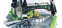
MARCUS YAM / The Seattle Times
A large American Flag flies at half staff on April 2 in the debris field caused by the massive Oso landslide.
![]()
SIX months ago, a rain-soaked hillside collapsed above the community of Oso in Snohomish County. Within minutes, a wall of mud raced down a forested slope and buried Steelhead Haven, a Stillaguamish River Valley neighborhood established in the 1960s.
Forty-three people, including seven children, were killed, making this the deadliest landslide disaster in U.S. history. Fatal landslides like this are not limited to the Pacific Northwest. In 2005, heavy rainfall triggered a similar slide that inundated La Conchita, Calif., killing 10 people.
The United States Geological Survey estimates that, on average, landslides kill 25 to 50 people each year in the U.S. There is a way to identify the communities most vulnerable to landslides and help them avert similar landslide disasters in the future.
Thousands of landslides occur nationwide each year, usually as localized events within large stretches of geologically active terrain. Despite progress, scientists still are not able to reliably predict the precise timing of these events. Thus, landslides pose significant challenges to public officials, who have enacted policies that focus on broadly identifying landslide-hazard areas.
Such was the case for the Oso region, where much of the nearby hillside terrain had been mapped as being susceptible to landslides. But these types of maps tell us little about the potential consequences of landslides. For example, does a hazard designation imply that a hillside will creep along at just a few inches each year, or does it instead suggest that a slope could collapse and run out over a community, as happened at Oso?
In fact, the most important issue — the risk to human life — is not explicitly considered in routine landslide-hazard assessments.
There is a better way. The field of landslide-risk assessment provides tools to consider the likelihood of a landslide as well as the potential consequences for people and communities.
The words “hazard” and “risk” often are used interchangeably, but there is an important distinction: “Hazard” simply implies that a landslide might occur, whereas “risk” tells us how likely it is that a landslide would harm people. Landslide-risk assessment provides more meaningful information on which officials and residents can base their actions.
Several other countries have already shifted their public policies in this direction. A recent example is in New Zealand, a geologically active country that has suffered many landslide fatalities in recent decades.
After five people were killed by landslides during the 2011 Christchurch earthquake, local-government officials committed to an ambitious initiative to map landslide-fatality risks in the region. This recently completed initiative produced maps that resemble flood maps commonly used in the U.S., but with the contours corresponding to life-safety risks posed by nearby landslides.
Today, the New Zealand landslide risk maps play a central role in local land-use policy and help to guide the rebuilding of the region. They also serve as an easy-to-understand tool for communicating with residents, in an objective and transparent way, the life-safety risks they face. The success of this initiative has led to planned risk-mapping in other parts of the country.
Mapping landslide risks is not simple. But technologies such as remote sensing, combined with improved analytical and probabilistic models, are making it easier, cheaper and faster to do than ever before. Perhaps the biggest challenge is for public officials who must decide what risk level is tolerable in their communities, as well as what to do about established residences and communities where risk to life is deemed to be unacceptably high.
Landslide-risk mapping alone could not have prevented the Oso tragedy. Only direct actions such as investing in hillside stabilization or keeping individuals out of harm’s path could have done that. This would have required the will of both public officials and the community.
But unlike traditional landslide-hazard mapping used today, risk mapping could have identified Steelhead Haven as a place where the chance of losing one’s life was very high, and where mitigation actions would have been warranted. It also could have informed community residents about just how risky a place Oso was.
Joseph Wartman is the H.R. Berg Associate Professor of Civil and Environmental Engineering at the University of Washington. He co-led the Geotechnical Extreme Events Reconnaissance team that investigated the Oso landslide.
 Four weeks for 99 cents of unlimited digital access to The Seattle Times. Try it now!