Originally published April 3, 2014 at 8:55 PM | Page modified April 4, 2014 at 11:05 AM
Monitoring can warn of impending slides — at a cost
Instruments that measure the movement of slopes that precede a landslide are common in some parts of the world but rarely used in Northwest.
Seattle Times science reporter
Oso landslide: Comprehensive coverage of the March 22 disaster and recovery

The Seattle Times
A collection of stories and visuals about the disaster, why it may have happened and the people it affected.
Interactive: Building toward disaster

THE SEATTLE TIMES
Use an interactive to see how, even as warnings mounted, homes kept being built in slide-prone Steelhead Haven.
Remembering the victims

Compiled by The Seattle Times
Read about the lives of the victims.
Interactive map: A detailed view of the neighborhood hit by the landslide

Garland Potts, Cheryl Phillips / The Seattle Times
Use an interactive tool to see the landslide’s deadly path.
TIMES WATCHDOG
![]()
In the weeks before the Oso mudslide, Shari Brewer and her husband noticed a change in the bluff that towered over the North Fork of the Stillaguamish.
A crack at the top of the slope was widening, but it didn’t seem like anything to be alarmed about. “It was just sliding down a little,” said Brewer, who lives west of Darrington. “It wasn’t a lot, but we could see that it was opening up.”
Jeffrey Moore isn’t surprised.
Large landslides don’t strike out of the blue, said the University of Utah geologist. Unstable slopes almost always creep, slough and sag long before they let loose. Monitoring that movement can provide lifesaving warnings, though the approach is rarely used in the Northwest.
“I don’t know why we don’t invest more in trying to pre-empt these disasters,” said Moore, before correcting himself.
“I do know why.”
Monitoring is costly. Few states have enough funds to even identify the most treacherous slopes.
In Switzerland, a landslide-prone hill like the one that collapsed and killed at least 30 people on March 22 would have been wired with sensors and surveyed at least twice a year for signs of movement, said Moore.
That country’s vigilance has averted multiple disasters in narrow, alpine valleys, where residents evacuated to safety before major slides came crashing down.
Kennecott’s Bingham Canyon copper mine in Utah sent workers home and relocated equipment the morning of April 10, 2013, based on monitoring with state-of-the-art radar and other methods. Later that day, a massive slide thundered through the pit.
“The technologies are out there,” Moore said. “This is something that people should really speak up for.”
But budgets for landslide work are “at the bottom of the pile” when it comes to geologic hazards, said Portland State University Professor Scott Burns.
Landslides are intermittent and don’t cause as much death and destruction as earthquakes or floods. That’s why the U.S. Geological Survey (USGS) devotes only $3 million a year to landslides and one reason why many states — including Washington — have cut back their efforts, he said.
There’s no federal inventory of landslide-prone slopes, and the existing USGS map dates to 1982. States and counties have lists, but most are incomplete.
Washington’s was compiled without input from a new, laser-mapping technique, which has revealed many previously unknown slide zones.
It’s impossible to monitor every landslide, Moore said. An effective program has to start by singling out the most dangerous ones: those like the Oso slide, which have failed in the past and loom over communities.
With new technologies like laser mapping and satellite imaging, that can be done, said Jonathan Stock, director of the USGS Innovation Center for Earth Science. That more and more communities are expanding into landslide-prone rural and suburban areas adds urgency.
“What people want to know is where the landslides are, when they might happen and how big they might be,” Stock said.
Time of failure
Monitoring can address the “when” question.
The movement that precedes most major slides usually starts slowly, then accelerates as collapse draws near, Moore explained.
“We use displacement trends to predict the time of failure.”
There’s a wide range of instruments that can detect and monitor those trends.
Some of the best are inserted in boreholes where they track what’s going on deep inside a hill.
Devices called inclinometers and tiltmeters can tell when slumping starts and how fast it’s proceeding. Piezometers detect changes in water pressure due to rain and runoff, which can force apart soil grains and weaken the bonds of friction that help keep slopes upright.
Other instruments scan the landscape for deformation. The same laser method used for aerial maps, called lidar (light detection and ranging), can be deployed on the ground to detect tiny bulges or slumps. GPS sensors can serve the same function. The newest ground-based radars are able to discern millimeter-level shifts.
The more intensive the monitoring, the higher the price tag.
Mining operations lead the way in landslide monitoring, because they have so much at stake, Moore said. A single ground-based radar can cost $250,000, and the Utah mine used six to pinpoint the timing of last year’s slide.
But it’s possible to devise a basic system that’s much less pricey, Moore said. In some Swiss valleys, surveyors take readings once or twice a year and only step up their efforts if they detect anything alarming.
Cheaper options are also in the pipeline. Engineers in Switzerland are developing wireless GPS instruments that can be linked in a network and cost about a thousand dollars.
Neil Dixon and his colleagues at the University of Loughborough in the U.K. are testing an acoustic system that provides continuous monitoring for an initial investment of less than $10,000.
Called Slope ALARM, it’s basically a metal pipe sunk into a hillside and filled with gravel. As the slope slips, the gravel rumbles; specially tuned sensors pick up that sound. The noisier it gets, the greater the chance of failure, Dixon explained.
At some predetermined threshold, the system sends out warnings.
No magic wand
Experts caution that there’s no way to know whether a monitoring system in Oso could have prevented the loss of life. Any effective warning system requires an understanding of the slope and its dynamics, Dixon said.
“None of these instruments are magic wands. You need engineering and geologic assessments ... to even decide where to put your instruments,” Dixon said.
Burns, of Portland State, would like to see the USGS gather that kind of baseline information and assess landslide hazards in Western Washington and Oregon in the same way the agency has sized up the risks posed by earthquakes.
“People can go to the computer and find out if they live in a flood plain or what the earthquake hazard is at their home,” Burns said. “But you can’t find out: ‘Where have the landslides occurred in the past? And how do I interpret that?’ ”
One of the key missing pieces is an understanding of why some slopes “go rogue” and fail catastrophically, as happened in Oso, said Stock, of the USGS.
But several studies are under way to help fill in that gap.
USGS scientists have been monitoring coastal bluffs in Oregon for nearly a decade and can now predict when those slopes will start to move based on groundwater levels. A similar project in Seattle led to a rainfall formula used to forecast when slides are likely.
State and local transportation departments across the Northwest regularly monitor unstable slopes above roadways, and can step in to improve drainage or reroute traffic when they see signs of trouble.
There’s also at least one landslide alarm system in Washington. Acoustic sensors along the Puyallup and Carbon River valleys are designed to sound the alert when they detect the ground shaking from a massive landslide called a lahar off the flanks of Mount Rainier.
For the most part, though, slide monitoring in Washington has come after the fact.
After a chunk of coastline peeled off Whidbey Island last year — threatening several homes, including one owned by former Microsoft CEO Steve Ballmer — Island County spent more than $300,000 to analyze the slope and install inclinometers and groundwater sensors.
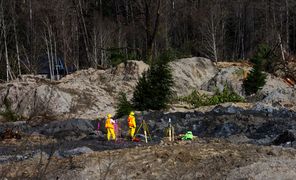
The Oso slide is now swarming with state and federal geologists. At a cost yet to be determined, they’ve installed instruments to detect any motion that might signal another slide. But instead of protecting homes and residents, the instruments are meant to safeguard the hundreds of emergency responders sifting through the debris for victims.
Sandi Doughton at: 206-464-2491 or sdoughton@seattletimes.com
 Four weeks for 99 cents of unlimited digital access to The Seattle Times. Try it now!


