Originally published March 28, 2014 at 8:32 PM | Page modified March 28, 2014 at 10:06 PM
Geologists monitor unstable slope as rain moves in
Experts are watching for cracks, sloughing and motion that could warn of new impending danger on the slope that collapsed into a massive mudslide a week ago in Snohomish County.
Seattle Times science reporter
![]()
Concerned that wet weather and unstable ground could unleash another landslide, geologists and engineers are keeping a close watch on the slope near the town of Oso that collapsed last week.
Monitoring so far shows no indication of imminent danger, said Washington State Geologist Dave Norman of the Department of Natural Resources.
But the entire area is vulnerable to landslides, he cautioned. “With the heavy rains and the amount going on, it’s going to take a lot of vigilance and continuous monitoring” to ensure the safety of crews combing through the debris, Norman said.
The top priority is the area where the search is under way, but scientists are also planning to expand their surveillance to other landslide-prone areas along the North Fork of the Stillaguamish.
“We’re exercising absolute caution,” said John Clemens of the U.S. Geological Survey (USGS), which dispatched several geologists to assist with the monitoring. “We don’t know what Mother Nature is going to throw at us.”
Teams installed instruments late this week to detect any signs of shifting or other movement in the landslide area, Norman explained.
Ground-based laser systems, on the lookout for deformation, are being used to scan the landscape several times a day. Surveyors are also taking readings from reflecting targets installed along a line of sight from the top of the slide to the valley floor.
And experts on the ground and in the air are scanning the hillside for cracks, slumps or other warning signs.
“You’ve got lots of pairs of eyes on this thing,” Clemens said.
The USGS is preparing to deploy at least two sets of instruments called “spiders,” developed to monitor erupting volcanoes. Supported on metal legs, the spiders contain seismometers, motion detectors and GPS sensors — and can be lowered by helicopter onto treacherous terrain.
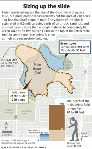
Early this week the Washington State Department of Transportation also conducted an aerial lidar survey, Norman said. The technique uses laser pulses to build a precise topographic map, and will help scientists better quantify the volume and thickness of the slide.
While major landslides release a lot of the tension stored in a hillside, they can also leave behind unstable slopes that can fail again. And when one slope slumps, the stress on adjacent areas increases, Norman said.
He and others surveyed the slopes on either side of the Oso slide and — so far — see no cause for alarm. But they haven’t yet expanded their surveillance up and down the valley, which is replete with slide-prone slopes.
Each hillside has its own, unique tipping point, said University of Washington landslide expert Dave Montgomery. Just because the Oso slide let loose is no reason to expect other slopes in the area to fail, he said. Continued rainfall does raise the risk, he added — though by how much, no one knows.
Sandi Doughton: 206-464-2491 or sdoughton@seattletimes.com
 Four weeks for 99 cents of unlimited digital access to The Seattle Times. Try it now!


